Tenerife Bluetrail is a 100km ultra marathon in Puerto de la Cruz, Spain. Distance: 100km. Elevation: 5,500m D+. Difficulty: challenging (Challenge Rating 58/100). DNF rate: 20%. Time limit: 24h. Surface: trail. Established 2011.
Tenerife Bluetrail
Puerto de la Cruz, Canary Islands, Spain
"100km from coast to Teide at 3,555m. Volcanic moonscape and cloud forest."
A volcanic 100K on Tenerife — from tropical coast to 3,555m.
The Course
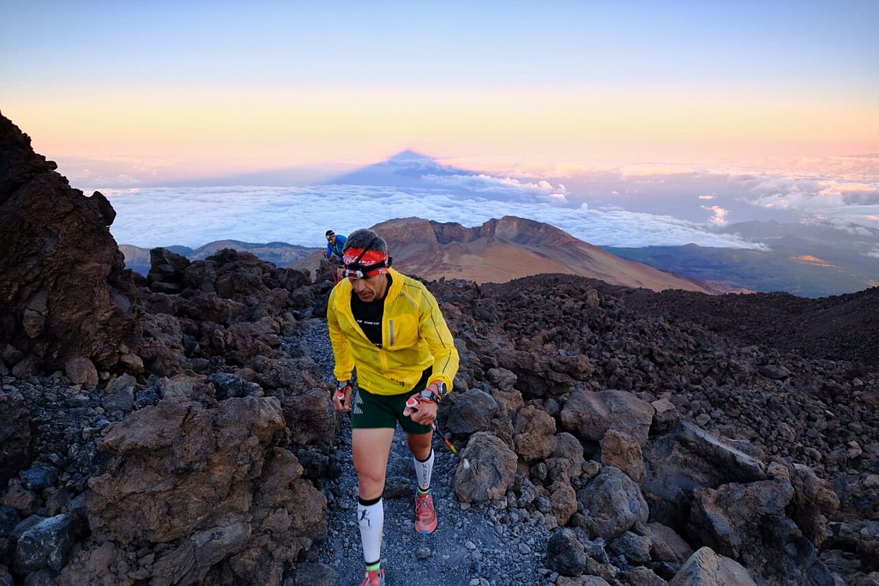
A 100km ultra circumnavigating Mount Teide (3,718m) on Tenerife in the Canary Islands. The route climbs from sea level through pine forests, volcanic badlands, and the high desert of Teide National Park — a UNESCO World Heritage Site that looks like Mars. The course crosses lava fields, black volcanic sand, and ancient laurel forest. The elevation profile is savage: 6,000m+ of cumulative gain as the route yo-yos between coastal valleys and the volcanic plateau.
mountainous
loop
8
3,555m
Runner Experience
Standard aid station support with food, drinks, and basic medical assistance at regular intervals.
Post-race celebration in a scenic coastal setting. Spain hospitality adds warmth to the finish line experience.
Race Day Weather
20°C
050%
10%
From tropical coast to freezing summit. Three climate zones.
Stats & Records
2011
300
18:00:00
Entry
€90
November
weeks
Lore & Trivia
Tenerife's Bluetrail circumnavigates Mount Teide — Spain's highest peak and the world's third-tallest volcanic structure from ocean floor. The course crosses terrain that NASA has used as a Mars analogue: red volcanic desert, black lava flows, and pumice fields where nothing grows. The Canary Islands ultra scene has exploded in the last decade, drawing European runners with year-round mild coastal temperatures that turn to alpine cold at the 3,000m volcanic plateau. The race name comes from the deep Atlantic blue visible from every ridgeline.
- ▸ Mount Teide at 3,555m is Spain's highest point.
- ▸ The volcanic moonscape was used to film Star Wars.
- ▸ Laurel cloud forest is a relic ecosystem from millions of years ago.
- ▸ Established in 2011.
- ▸ Total elevation gain: 5500m.
Running around Teide at 3,000m — the volcanic landscape looks like Mars, the sky is infinite, and the Sahara is visible on the horizon.
Compare with another race
Similar Races
18 APR 2026
Penyagolosa Trails MiM
Castellón de la Plana, Spain
12 APR 2026
Salomon Ultra Pirineu
Bagà, Spain
9 MAY 2026
Transvulcania Ultramarathon
Los Llanos de Aridane, Spain
12 APR 2026
Ultra Sierra Nevada
Granada, Spain
Frequently Asked Questions
How long is Tenerife Bluetrail? +
Tenerife Bluetrail is a 100km (100km) ultra marathon with 5,500m of elevation gain. The course is loop on trail terrain.
How hard is Tenerife Bluetrail? +
Tenerife Bluetrail is rated challenging with a Challenge Rating of 58/100 (Challenging). The DNF rate is 20%. Runners have 24 hours to finish.
What is the weather like at Tenerife Bluetrail? +
Average temperature is 20°C with 50% humidity and a 10% chance of rain. From tropical coast to freezing summit. Three climate zones.
Are crew and pacers allowed at Tenerife Bluetrail? +
No crew access is permitted. Pacers are not allowed. Mandatory gear is required.
What is the average finish time for Tenerife Bluetrail? +
The average finish time is 18:00:00. About 300 runners finish each year. The DNF rate is 20%.
Are you the organizer? Claim this race
Stay in the loop
New races, course records, and stories from the trail — monthly